My parents decided they wanted to buy a pickup camper this winter, and offered to let Molly and me borrow it. Since we usually need a break from winter by this point in the year, we decided to try it out for them by heading to Arkansas, a state that Molly hadn’t been to before and one that I’d only visited briefly for work. It was a great way to pandemic-travel: since we carried our bed, kitchen, and bathroom with us, we really only had to come in contact with people when getting groceries and going to the thrift store, which is pretty close to our level of interaction when we're at home.
Friday, March 12: Lake Park, Iowa to Nevada, Missouri
We drove from Minneapolis to my parents’ the night before, got up in the morning, loaded the camper, and hit the road. We stopped in Sioux City to visit my sister and then continued on to Nevada, Missouri, where we stayed in an RV park. It rained all night, which would've made for a rough night if we'd been tent camping, but it was just kind of loud in the camper.
I can't recommend the scenery along the drive from Sioux City to southern Missouri on the interstate (29 to KC, then 49 south from there) very highly, but at least we made decent time.
Saturday, March 13: Nevada, Missouri to Fayetteville, Ark.
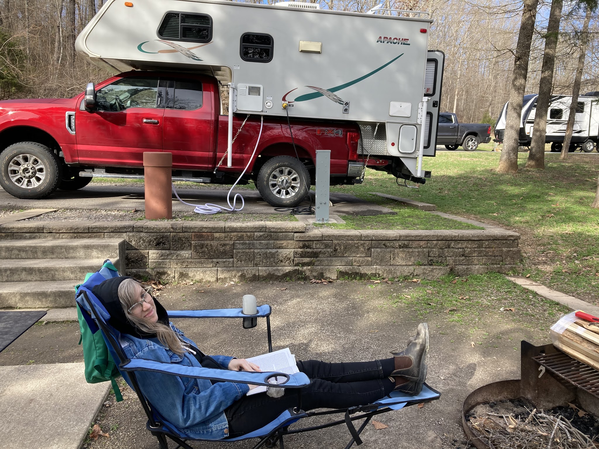
It was still raining pretty hard when we left the campground, but it cleared up by the time we got to Bentonville, Ark., home of the Crystal Bridges art museum (brought to you by Wal-Mart). Molly always like to see James Turrell's work whenever she gets a chance, so we checked that out on our way through. Molly made us some sandwiches in the camper, and we pulled out our lawn chairs and tailgated in the spacious overflow parking lot before walking around and checking out some art. It was a perfectly nice thing to do for free. There are only so many free things available, and it's accessible and appropriate for all ages. Somehow, I was able to not take any photos of any of the art, but here's a selfie of us tailgating:
Tailgating at Crystal Bridges
Afterward, we picked up a snack from Flying Fish, which was pretty good, especially the key lime pie. Bentonville was not that cool, but it has a lot of bike trails. We stayed at the world's trashiest RV park in Fayetteville, within a stone's throw of five bail bonds businesses and a Tyson chicken processing plant.
Sunday, March 14: Fayetteville, Ark. to Fort Smith State Park, Ark.
Stonks
We packed up the camper in the morning and tooled around Fayetteville (home of the main campus of the University of Arkansas) for a bit. We picked up some egg sandwiches from Farmer's Table, which were huge, and the biscuits were really good. Downtown was pretty dead, probably because it was spring break for the college. There were lots of good thrift and vintage stores, but everything except Goodwill was closed with it being Sunday, so we got groceries at Harps - the Arkansas Cub equivalent - and headed to Fort Smith State Park. It started raining hard as we left Fayetteville and didn't really let up until after dark. The park facilities and campground are super nice, but we didn't get to see a lot of them yet.
Monday, March 15: Fort Smith State Park and Devils Den State Park, Ark.
Devil's Den big rock
Weird erosion patterns at Devil's Den
We drove to Devil's Den State Park, which is about 45 minutes from our campground. We went on a really nice hike on the Devil's Den Trail, which was about 1 1/2 miles. There were lots of rocky outcroppings and unusual erosion, and wild fissures between huge rock formations.
Both parks are in a very rural part of the state - no stores or churches or gas stations anywhere in between or for miles in any direction.
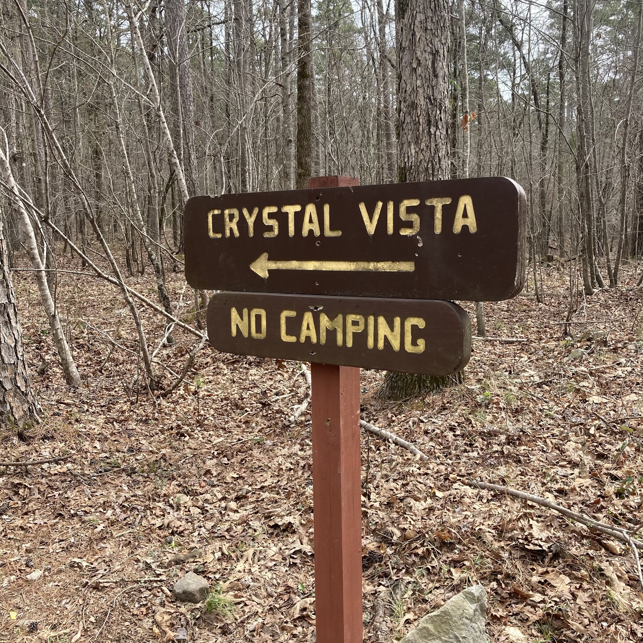
Tuesday, March 16: Fort Smith State Park to Crystal Vista to Mount Nebo State Park, Ark.
Crystal Vista senior picture
Glad to see this sign after weaving down some country roads
Quartz seam in sandstone at Crystal Vista
Crystal Vista outside of Mt. Ida was awesome - an old quartz mine at the top of a steep path where you can search for crystals just lying on the ground. Molly has now gone full rockhound.
We're staying at Mt. Nebo State Park tonight and tomorrow night, and it's quite the setting - a tabletop mounted surrounded mostly by flat ground. It's an interesting camping situation because the road to the park has ridiculous switchbacks and up to an 18% grade, so there's a strict limit on the size of the RV allowed. So, it's mostly tent campers and small trailers, and it started storming at about 3 a.m. Yay!
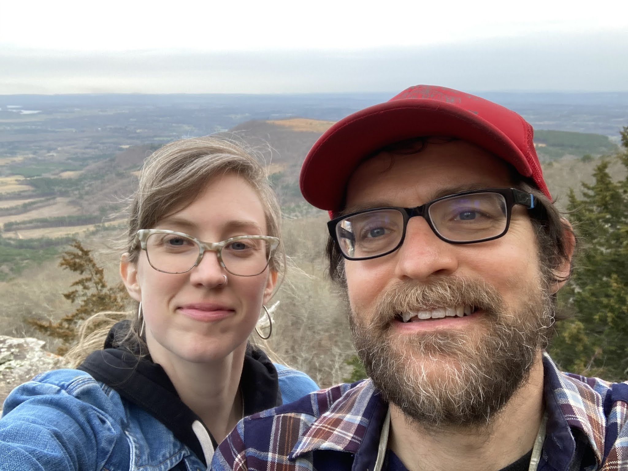
Wednesday, March 17: Mount Nebo State Park and Russellville/Dardanelle, Ark.
Waffle House visit #1 is delightful
Mt Nebo overlook selfie
Our campsite at Mt Nebo State Park
We went to Russellville for Waffle House, groceries, and some thrifting. None of the thrift stores were great and it didn't seem like there was much else to do, so we headed back to the park. Fortunately, the Waffle House was excellent and there was Cheetos mac & cheese available at the Kroger, so it was a good day.
The wind was blowing like a hurricane all night and there weren't many trees to stop it. The camper was rocking back and forth pretty firmly, and it was difficult to sleep. There were still a couple of tents in the campground in the morning, and I have no idea how they made it work. Nebo is really nice, but it seems to get some wild weather.
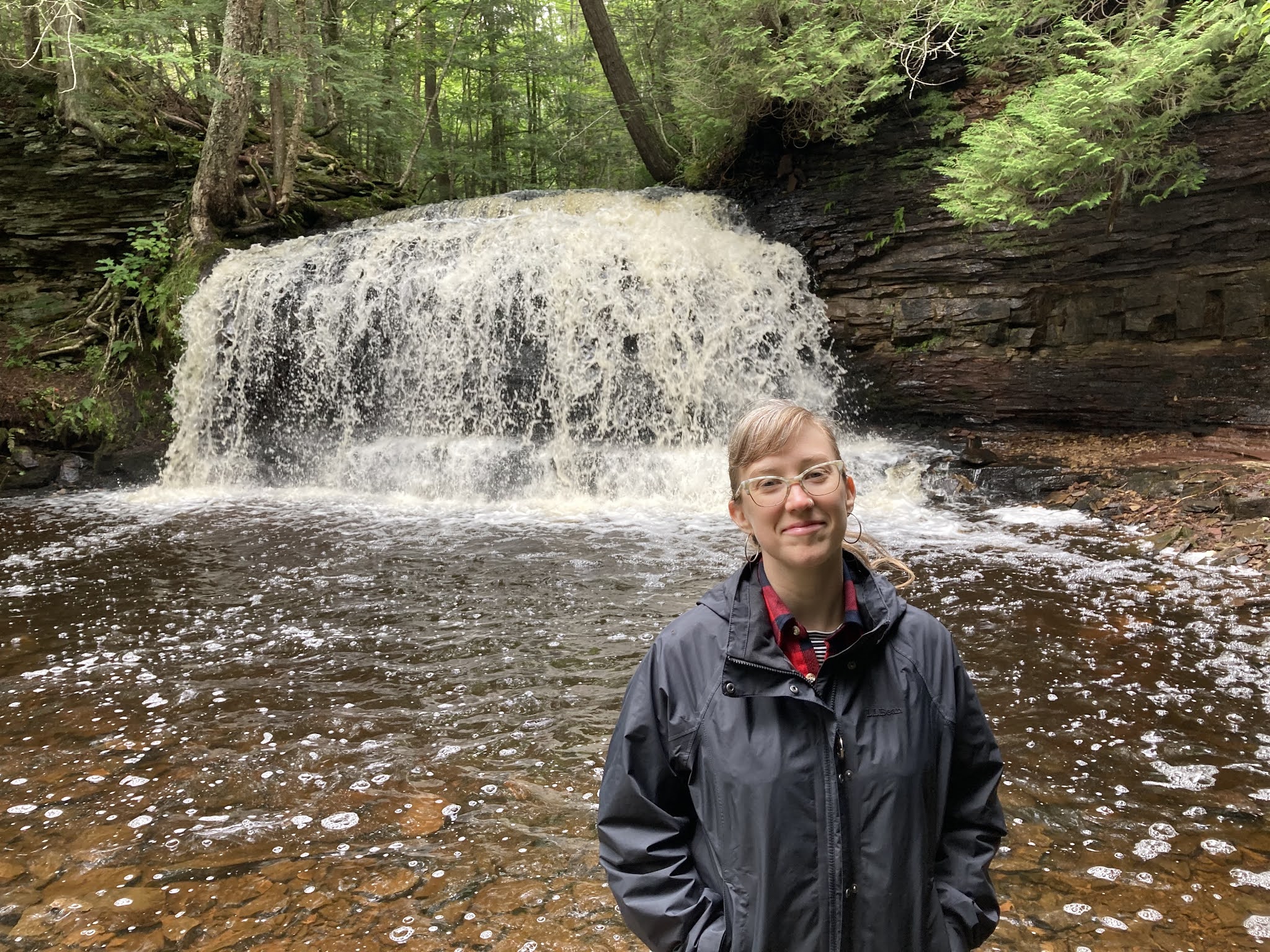
Thursday, March 18: Mount Nebo State Park to Petit Jean State Park, Ark.
All over Arkansas, rocks are just poised to crush you
Majestic Cedar Falls viewed from a remove
Arkansas state parks continue to be impressive, and the trail markings are the best either of us have seen. We drove about 40 minutes to Petit Jean (pronounced Petty Jeen) State Park, where we stayed for one night. It's a larger park with more than a hundred campsites, but it didn't feel crowded. We planned to do the Cedar Falls trail, but it was closed, so we did Cedar Creek instead, which was really pretty.
Friday, March 19: Petit Jean State Park, Ark. to Pomme de Terre State Park, Missouri
#shittyarmadillopicstakeone
#shittyarmadillopicstaketwo
Arkansas is redneck, but charming, and their state parks are fantastic (sample size = 4). Missouri is redneck, but boring, and their state parks ain't shit (sample size = 1). We picked up some Arkansas beer in Morrilton and drove a few hours through Branson and other Ozark splendor to get to Pomme de Terre State Park. It was almost completely empty and had a post-apocalyptic feel to it, but at least there was an armadillo? And the electric hook-ups worked, so we could run the furnace in the camper, because it got down to about 30 degrees overnight.
Saturday, March 20: Pomme de Terre State Park, Missouri to Lake Park, Iowa
Waffle House visit #2 is transcendent
This was a long driving day, highlighted by a Waffle House stop in suburban Kansas City.
In summary, I have to say that if your parents want to buy a camper and let you use it, then you should take them up on that.
I recently got a new job and quit my old one, and I had several weeks of built-up vacation from my old job that I cashed out when I quit. Since I'd be paid for not working for a few weeks and my new employer wasn't in a big hurry for me to start, Molly and I decided to take a road trip. It's been a weird year for everything, travel included, and we'd been sticking to short camping and cabin trips. At this point in the year, we thought we could responsibly do a longer driving trip to a lightly-populated area where we'd do a mix of camping and hotel stays.
Our original plan was to head West to the Dakotas and Wyoming, but there were enough wildfires and fire restrictions in that direction that we didn't think we could stay warm enough camping. So, our Plan B was to head south through Missouri and Arkansas and back through Memphis and Land Between the Lakes in Kentucky. However, as soon as we got that plan roughed out, two tropical storms began their path through the gulf, which would have sent five-plus days of rain to the Ozarks starting right when we were going to arrive at our first campsite. Since Canada is currently off-limits, we decided the U.P. was our best bet. Neither of us had been there before, and Molly hadn't experienced the joys of the lower peninsula, either. It was pretty good! Thanks to everyone who loaned us camping gear and gave advice on where to go and what to do.
Here's the basic outline of our route:
And here's a day-by-day blow-by-blow (please feel free to just click on one of the pictures and flip through them rather than reading my ramblings):
Friday, August 28: Two Rivers, Wisconsin
We drove from Minneapolis to Two Rivers, Wisc., stopping at the Thorpedo Family Restaurant in Thorp, Wisc., for lunch.
We checked into the Lighthouse Inn, walked over to the Hamilton Wood Type Museum and got a great tour from Molly’s friend from college, Stephanie, who is the museum director.
Keeping it in perspective at Hamilton
We saw a pantagraph machine in operation and saw some of the museum’s collection of type from the Enquirer Printing Company. We had drinks with Steph and Molly’s college professor Tom on a balcony with a view of Lake Michigan. We went to Kurtz’s Bar for takeout and took it to the Schwartz House for a surprise Frank Lloyd Wright house tour. It was all pretty delightful.
Saturday, August 29: Marinette to AuTrain Lake Campground, Michigan
We had a very nice breakfast from the Lighthouse’s in-house restaurant and then hit the road for the UP. We got some great Thai food at Thai Express in Marinette, Mich., right after crossing the state line, and ate it next door on the shore of Lake Michigan, behind the Little Caesars and a health clinic. The only town of any size that we encountered after Marinette was Escanaba, where we stopped at a couple of thrift stores. Their school mascot is the Eskymos, complete with slant-eyed mascot on the water tower and everything. Yay.
That Eskinaba Mood, distilled
After a stop for a short hike to check out AuTrain Falls, we made it to AuTrain Lake Campground in Hiawatha National Forest and set up camp. It was a tough night to make a fire, as it had rained earlier in the day and the wood we gathered was pretty wet, plus it was quite windy.
Sunday, August 30: Rock River Falls and Miner's Beach, Michigan
We headed from the campground to the Rock River Falls trailhead, which wasn’t very far distance-wise, but took forever because of some of the worst road I’ve ever driven on. It was more than our Passat wagon with limited ground clearance was expecting, but not more than it could handle. Check it out:
It was an all right hike and a decent waterfall, but all kinds of mosquitoes. It wasn’t a great bang for our buck.
We felt like we had to take several photos to make it worth it
Team Zissou audition photo
From there, we drove to Munising, where Molly got an ice cream cone and some postcards while I zip-tied the plastic shroud on the front of our car back in place, which had come loose while driving through potholes on the way to Rock River Falls. We started at Munising Falls and Miner’s Castle, which were both a short walk from an easily-accessible parking lot, and were therefore very crowded. Next, we went to Miner’s Beach, which was slightly less easy to get to, much less crowded, and very cool.
We waded through a tea-colored stream, sat on a rock and watched a couple get engaged. It was very nice. We bought some firewood on the way back to camp which turned out to be wet, too. Molly made rice and beans, which was very good. The fire was bad, though, and it was a very cool, damp, and windy evening, which I hadn’t packed enough layers to stay warm enough to sleep in.
Monday, August 31: Pictured Rocks National Lakeshore, Michigan
We woke up, disassembled camp, and walked over to the observation deck adjacent to the campground on AuTrain Lake. We drove to Munising, and as soon as we got cell service, I received a voicemail that our kayaking trip along Pictured Rocks National Lakeshore was cancelled because of high winds. So, we went hiking to Chapel Rock instead. It was hard, but the view was worth the climb, metaphorically speaking.
Chapel Rockin'
It was about a 7 mile hike over fairly flat terrain. The views along Lake Superior were great, and I think we got the idea even though we didn’t do the full 10-mile loop. We drove to Marquette, got takeout from Sol Aztecas mexican restaurant, checked into the Quality Inn, and collapsed.
Tuesday, September 1: Marquette, Michigan
We had breakfast at the hotel and went to Salvation Army so I could pick up a couple of extra layers for the nights that we were still to camp. We stopped at Koin King Laundromat and walked to the Superior Dome and through the neighborhoods around Northern Michigan University while our clothes washed and dried. We got lunch at the Fish Mqt food truck (fish & chips and fish tacos) and stopped at the St. Vincent de Paul on the way to Presque Isle, which is I believe a Marquette city park. It's a peninsula into Superior, close to town, and gorgeous.
Black Rocks from afar
Superior Dome looming
We scrambled on the Black Rocks and sat on a rocky beach. We took a rest stop at the hotel and went back to town and found a patio at Ore Dock Brewery after some looking. We got some ice cream at a local drive-in and talked to a friendly dad, and then we stopped a the food coop and got some cold-bar dinner, which we took back to the hotel and ate after we had some time in the hot tub.
Wednesday, September 2: Sugar Loaf Mountain and Hungarian Falls, Michigan
I got up and headed to the Econofoods across the parking lot from our hotel and found some Karo pancake syrup -- which is apparently extinct in Iowa and Minnesota grocery stores -- to bring back for my parents. After breakfast at the hotel, we checked out and headed to Sugar Loaf Mountain, which is just a few miles outside Marquette. It wasn’t a very long hike from the parking lot to the summit, maybe 25-30 minutes, but the view was really fantastic.
Atop Sugar Loaf
You could see downtown Marquette, Presque Isle, the adjacent peak of Hogback Mountain, and a panorama of Lake Superior. It’s highly recommended. We stopped for lunch at Ralph’s Italian Delicatessen in Ishpeming, and it was fantastic.
They have a sign outside so you can tell where they're located
We learned what a cudighi is (“a spicy Italian sausage seasoned with sweet spices that can be bought in links or served as a sandwich on a long, hard roll, often with mozzarella cheese and tomato sauce”) and ordered an Italian hero and an antipasto salad. We ate at a picnic table in the Al Quaal recreation area, which was a really nice city park with some of the tallest swingsets you’ll ever see. We tried those out and were satisfied. We drove to Houghton and Hancock, home of Michigan Tech, and stopped at their St. Vinny’s, which was weird. From there, we proceeded to Hungarian Falls, which was also excellent bang for our hiking buck (maybe 2 miles total of hiking got you views of three very solid waterfalls).
Our destination for the night was McLain State Park, and we drove through the faded copper mining towns of Laurium and Calumet on the way there. Some of the old buildings in Calumet were very cool. We were camping pretty close to the highway at the state park, but fortunately (?) the wind and sounds of the crashing surf from Lake Superior drowned out the traffic noise. Molly was an excellent tarp engineer and kept us dry, even though we had to get up in the middle of the night to re-pound one of the tarp stakes that had blown loose.
Thursday, September 3: Keeweenaw Peninsula, Michigan
Molly ended up sleeping in the car part of the night, which was quieter and better for her. We got a later start, but it was raining until 9:30 a.m. anyway, so we weren’t going to be able to do a whole lot outside anyway. We had breakfast at the campsite and headed north up the west side of the Keeweenaw Peninsula, Our first stop was at Jampot, a pastry and preserves shop run by the Society of St. John, where we met the nicest monk. The power was on & off while we were there, but we were able to get some pastries and jams without difficulty.
We drove on the Brockway Mountain Drive, which is supposedly the highest paved road between the Rockies and the Adirondacks. It was exceptionally windy the whole way, and at the overlook parking lot, there was a sign hanging by a thread.
We somehow angered the sea gods.
After passing through Copper Harbor, we reached the end of U.S. Highway 41, and stopped at Ft. Wilkins Historic State Park on the way back into town. We bought some postcards in the gift shop and tried without success to find an old printing press in the restored barracks.
Very honest signage
Ft. Wilkins wasn't a coveted posting
A few miles outside of Copper Harbor (after mailing some postcards at the Copper Harbor post office), we hiked the Estivant Pines loop, which featured gigantic 500-600 year old pine trees.
Very important: we saw a turtle crossing the gravel road while driving back after the hike. We tried to find the Mandan ghost town, but couldn’t locate anything other than a few old houses that were well-maintained and obviously occupied. We stopped at the Central Mine ghost town, where we saw the powder building and schoolhouse ruins, and Molly’s Appalachian dream house.
Powder Building at Central Mine
A little less intact at the other end
We bought some firewood and headed back to camp for some tuna melts; our attempt to watch the sunset on the Superior beach adjacent to the campground was unsuccessful because of what had to be 40 mph winds and 50 degree temperatures.
Stupid Sexy Smokey
Friday, September 4: Ontonagon and Lake of the Clouds, Michigan
We had breakfast and broke down the camp at McLain State Park and hit the road. We drove back through Houghton and stopped at Goodwill (where Molly did pretty well) and Econofoods for a grocery and water re-up. We took a slight detour to Old Victoria mining ghost town. All the buildings were closed per COVID, but there were cool old log cabin-type buildings. We stopped for lunch in Ontonagon and tried our first pasty of the trip from Syl’s Cafe. It was dry and bland, so we didn’t feel like we’d really been missing out on much up to that point. We ate our food on the Superior beach, and it was -- wait for it -- extremely windy. Molly scored at the St. Vinny’s with some sweet vintage sweaters. There were lots of ATV folks derping around on main street in Ontonagon. From there, we drove on to the Porcupine Mountains, where we summited the Lake of the Clouds overlook after an epic 5-minute walk from the parking lot.
No one had ever photographed Lake of the Clouds before; you're welcome
Molly was super burned out on hiking by this point, and with it being the beginning of the Labor Day weekend, all the trailheads were very packed with mostly jerks, so we opted out and headed to a beach near our campground. Molly went agate hunting while I read before we retired to Site #79 at the Union Bay Campground for some beans and rice goodness.
Saturday, September 5: Watersmeet and Ironwood, Michigan
We got up and broke down camp at Union Bay and headed to the camp store to ask about the canoe rentals that were advertised. It was the first time in several days that the winds were anywhere near calm, but they weren’t renting today because of either “weather” or “possible future weather.” The Porkies were getting more crowded by the minute, so we drove to Berglund instead, where it was rumored that there were businesses that would actually rent canoes. This turned out to be false, but they sold gasoline at least, which we needed. We finally found a canoe rental place in Watersmeet, Sylvania Outfitters, which I cannot recommend highly enough. Even though they weren’t located on the water, they rented us a canoe for $28 for the whole day, which included blocks and straps and help to load and unload it off our car.
Blocked, chocked and ready to rock
After some fruitless effort to find a boat launch on Sucker Lake (should have seen that coming, I guess), we located a launch on Bass Lake and had a nice paddle for a couple hours, including some lunch on the water. After returning the boat, we headed westward on U.S. Highway 2. We stopped to see a cool old stone arch railroad bridge in Ramsey (the Keystone Black River Bridge), which is now part of the Iron Belle Bicycle Trail, which I believe had just opened that day.
Some sweet bridge-in-bridge action
It was adjacent to a very nice city park in a town that otherwise wouldn’t have looked out of place in West Virginia. After a grocery stop at Super One Foods for bourbon, mint, and a chicken thigh (don't ask), we had a beer at Cold Iron Brewing in Ironwood. Based on the bartender’s recommendation, we grabbed a pizza at Pizza King Joe, which was a super weird building, but the pizza and junk salad (very little lettuce, mostly tomatoes and pickled vegetables and mushrooms) were both excellent. We checked into the beyond-excellent Cedars Motel and settled down with some mint juleps to watch the Kentucky Derby, as one does on Labor Day weekend. It was an odd, good time.
Much respect for the UP never putting the area code on any phone numbers
Beautiful
Sunday, September 6: Cornucopia, Wisconsin and Points Southwest
After some breakfast in our room, we checked out and headed out for Cornucopia, Wisconsin (“The Northernmost Village In Wisconsin” per the sign -- near the Apostle Islands) for some kayaking on Lake Superior. Lost Creek Outfitters proved my no-one-has-actually-ever-rented-a-boat-on-Superior theory wrong and actually let us kayak, which was very nice. The 3-hour tour took us along some beautiful near-vertical sandstone cliffs near Romans Point and through an arch, but the water was too high to get into any sea caves, which was fine. The wind picked up on several occasions, making it hard to make much progress when we were going into it or in a crosswind, but we weren’t ever nervous about tipping over. It was also 10-15 degrees warmer than it had been most of the rest of the trip, so we stayed pretty warm even though we got splashed with water quite a bit. I was pretty much spent by the time we got back, and I was glad that the half-day tour had been sold out. We drove back along the rest of the south shore of Superior to Duluth, where we got sandwiches at Northern Waters Smokehouse and headed for home.
In Conclusion
Most of whatever industry ever existed on the UP went away more than 100 years ago, and agriculture is non-existent, so it's pretty much tourism (and logging?) or bust from what we could tell. Unfortunately, a lot of that in the summer is ATV-trails goons who don't wear masks ever. The landscape and condition of the buildings look very Appalachian in a lot of spots, which probably owe a lot to the extractive industries that are historically found in both areas. Things look kinda meth-y in a lot of spots. There's very little wildlife -- even songbirds -- anywhere that we were, which was kind of unsettling. The wind stopped blowing as we were exiting Michigan for Wisconsin, which was nice, but boy did it stick around for pretty much the whole time we were in the state. When Superior isn't churning, though, the water is clear and a gorgeous turquoise color. There are so many waterfalls, and their quality has little or no relation to how difficult they are to access, so it's not really worth messing with anything that's too hard to get to. A lot of the streams and rivers flowing into Superior are high in either/both iron and tannins, so there's often a transition area where the dark streams blend into the clear lake. It's pretty tough to find any sweet, secluded camping spots when you're booking your trip a week in advance. As the week went along, our camping skills (especially fire-building) improved, but the quality of our spots went downhill.
In summary, the Upper Peninsula is a land of contrasts.


